
Quick answer
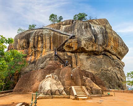
Sigiriya is laid out along an east-west axis centred on the rock. The western precinct, enclosed by an inner and outer moat, holds the water gardens, followed by the boulder gardens and terrace gardens at the foot of the rock. The route then climbs the western face to the fresco gallery and mirror wall, turns to the lion's paw terrace on the north side and ascends to the summit palace. A smaller eastern precinct lies on the far side.
Key takeaways
- Sigiriya is organised along an east-west axis running from the western gate to the rock.
- The western precinct, enclosed by two moats, holds the water gardens and is the main visitor approach.
- The route runs water gardens, boulder gardens, terrace gardens, fresco gallery, mirror wall, lion's paw terrace, summit.
- The summit palace covers roughly 1.5 hectares on top of a rock roughly 200 metres above the plain.
- Visitors generally enter from the west and leave by a different route down the south or east side.
The east-west axis
The whole Sigiriya site is organised along a straight east-west axis. It runs from the western gate, through the centre of the water gardens, to the foot of the rock, and the gardens on either side are arranged symmetrically around it.
The axis is the single most important thing to understand about Sigiriya. It turns the approach into a procession, focuses every view on the rock, and shows that the city was planned as a whole rather than built piecemeal.
The precincts
Sigiriya divides into several zones. The western precinct is the largest and most elaborate, and it is where visitors enter. A smaller eastern precinct on the far side of the rock is less restored and less visited.
- →Western precinct: enclosed by inner and outer moats, holding the water gardens.
- →Boulder gardens: natural boulders at the foot of the rock, adapted into caves and platforms.
- →Terrace gardens: brick-and-stone terraces around the base of the rock.
- →The rock face: the fresco gallery, mirror wall and gallery path.
- →The lion's paw terrace: the northern plateau and gateway.
- →The summit: the palace, roughly 1.5 hectares.
- →Eastern precinct: a smaller, less restored area on the far side.
The route through Sigiriya
Sigiriya's visitor route follows the ancient sequence. You enter at the western gate near the ticket office and museum, cross the outer and inner moats and walk the central axis through the water gardens. The path then winds through the boulder gardens, climbs the terrace gardens, and reaches the rock face.
From there, a spiral staircase leads up to the fresco gallery, and the gallery path leads past the mirror wall round to the lion's paw terrace on the north side. The final metal stairway then climbs to the summit.
- →Ticket office and museum at the western entrance.
- →Outer moat, inner moat, water gardens along the axis.
- →Boulder gardens and terrace gardens.
- →Spiral staircase to the fresco gallery.
- →Mirror wall and gallery path round to the north.
- →Lion's paw terrace, then the final stairway to the summit.
Going down: a different way out
At Sigiriya the descent generally follows a different route from the ascent, returning to the lion's paw terrace and then taking a separate path down the south or east side. It usually passes more boulders and caves before leaving the site through an exit area with stalls.
The exit is not at the western gate, so agree a pick-up point with your driver before you start. Most drivers know the standard meeting point at the exit car park, but it saves a long walk back if you confirm it.
Using the layout on your visit
Knowing Sigiriya's layout helps in three practical ways. It tells you where the shade ends, which is above the boulder gardens. It tells you where the bottlenecks are, which are the spiral staircase and the final stairway. And it tells you where to look back, which is from the gallery path and the summit.
Lankan Stays & Trails guides start every visit at the site model in the museum or on a signboard, because five minutes with the plan makes the next three hours far richer.
- →Shade ends above the boulder gardens.
- →Bottlenecks: the spiral staircase and the final stairway.
- →Look back from the gallery path and the summit.
- →Agree a pick-up at the exit, not the entrance.
Frequently asked questions
How is Sigiriya laid out?
Sigiriya is laid out along an east-west axis running from the western gate to the rock. The western precinct holds the water gardens inside two moats, followed by the boulder and terrace gardens, the rock face with the frescoes, the lion's paw terrace and the summit palace.
Where is the entrance to Sigiriya?
The main visitor entrance is on the western side, near the ticket office and the Sigiriya Museum. From there the path crosses the moats and follows the central axis through the water gardens to the rock.
Is the exit at Sigiriya the same as the entrance?
Generally not. The descent usually takes a separate route down the south or east side and leaves the site through a different exit area. Agree a pick-up point with your driver before you start.
What is the route up Sigiriya?
Water gardens, boulder gardens, terrace gardens, a spiral staircase to the fresco gallery, the gallery path past the mirror wall, the lion's paw terrace on the north side, then the final stairway to the summit palace.
Is there a map of Sigiriya?
There are site plans on signboards at the entrance and a model of the whole site in the Sigiriya Museum near the ticket office. Looking at either before the climb makes the route and layout much easier to follow.
What is the eastern side of Sigiriya like?
The eastern precinct is smaller and less restored than the western one, and far fewer visitors see it. The standard descent route may pass near it. Ask your guide what is accessible on the day.