
Quick answer
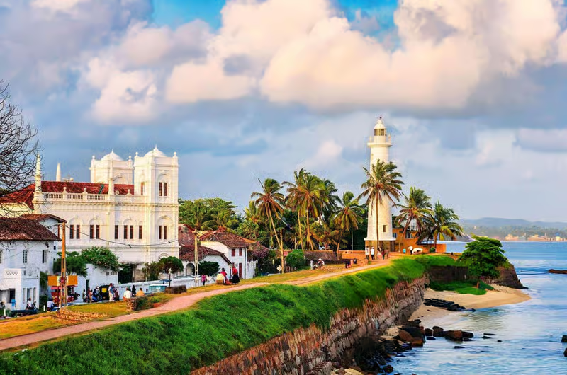
Galle Fort is a fortified old town on Sri Lanka's south coast, founded by the Portuguese in 1588 and extensively rebuilt by the Dutch from 1649, and inscribed as a UNESCO World Heritage Site in 1988. Its ramparts enclose roughly 36 hectares in a grid of Dutch colonial streets, with fourteen bastions, an 1883 British lighthouse, the 1755 Dutch Reformed Church and the Meeran Jumma Mosque. It remains a living town rather than a museum, and the ramparts can be walked in about an hour.
Key takeaways
- The Portuguese founded the fort in 1588; the Dutch rebuilt it substantially from 1649 onwards.
- Galle Fort was inscribed as a UNESCO World Heritage Site in 1988.
- The ramparts run roughly 3 kilometres around fourteen bastions and can be walked in about an hour.
- The Dutch Reformed Church dates from 1755 and has a floor paved with old gravestones.
- The fort is still a working residential town, not a reconstructed heritage site.
Three empires, one headland
The Portuguese fortified this rocky peninsula in 1588, after using Galle as a trading harbour for decades. Their fort was modest, concentrated on the landward side, and it did not save them: the Dutch East India Company took Galle in 1640 after a short and violent siege.
What you see today is overwhelmingly Dutch. From 1649 the VOC rebuilt the defences on a far more ambitious scale, throwing a granite and coral rampart around the entire peninsula with fourteen bastions and a moat cutting the landward approach. The British took over in 1796 and changed relatively little, adding the clock tower and, in 1883, the lighthouse. That layering, Portuguese footprint, Dutch structure, British fittings, is the fort's architectural story in one line.
- →1588: Portuguese fortification of the headland.
- →1640: Dutch capture Galle from the Portuguese.
- →1649 onwards: VOC rebuilds the ramparts and bastions on a far larger scale.
- →1796: British takeover; clock tower and 1883 lighthouse added later.
Walking the ramparts
The rampart walk is the single best thing to do in Galle, and it takes about an hour at a slow pace. Start at the Main Gate on the landward side, where the British cut a wider entrance through the Dutch defences, and walk anticlockwise past the Star, Moon and Sun bastions, which guard the narrow neck of the peninsula.
The seaward stretch, past Aeolus, Clippenberg, Neptune, Triton and Flag Rock, is where the fort turns spectacular. Flag Rock at the southern tip is the sunset gathering point, where local lads dive from the wall into a narrow channel of deep water for tips. Behind the lighthouse the wall runs on to Point Utrecht Bastion and back to the harbour side.
- →Roughly 3 km around, about an hour at a slow pace.
- →Landward bastions: Star, Moon and Sun, guarding the peninsula's neck.
- →Seaward bastions: Aeolus, Clippenberg, Neptune, Triton, Flag Rock, Point Utrecht.
- →Best at sunrise for quiet, or the last hour before sunset for the light.
The buildings worth stopping for
The Dutch Reformed Church of 1755 is the fort's most affecting interior. Its floor is paved with gravestones moved from an older Dutch cemetery, carved with skulls, hourglasses and the names of company officials who died a long way from home. The organ loft and the carved pulpit are original.
The Meeran Jumma Mosque, at the southern end near the lighthouse, is a striking white building that reads at first glance like a church, complete with twin towers, and reflects the fort's long-established Muslim community. All Saints' Anglican Church, the Old Dutch Hospital now converted to shops and restaurants, the Maritime Museum in a Dutch warehouse, and the National Museum in a 1656 building complete the list.
- →Dutch Reformed Church, 1755: gravestone floor, original pulpit and organ loft.
- →Meeran Jumma Mosque: white twin-towered mosque near the lighthouse.
- →Old Dutch Hospital: 17th-century building, now shops and restaurants.
- →Maritime Museum and National Museum, both in original Dutch structures.
Reading the streets
The fort's layout is a Dutch colonial grid, and the street names still record it: Pedlar Street, Church Street, Lighthouse Street, Leyn Baan Street, Hospital Street. The characteristic house type is a long, narrow plot with a columned veranda facing the street, a central courtyard, and high ceilings with fanlights above the doors to move air, which is a genuinely effective climate response.
The Dutch also built a sophisticated sewerage system that used tidal flow to flush the drains, which is more than the modern town outside the walls can claim. Look for the coral and granite construction of the walls themselves, and for the VOC monogram on the Old Gate.
- →Dutch grid plan with original street names still in use.
- →House type: narrow plot, columned street veranda, courtyard, high ceilings.
- →Coral and granite rampart construction, visible where the render has gone.
- →VOC monogram carved above the Old Gate on the harbour side.
A living town, not a museum
Around four thousand people live inside the walls, in a mixed Sinhalese, Muslim, Burgher and Tamil community that has been here for generations. There are schools, mosques, temples, churches and corner shops alongside the boutiques. The tension between that community and the fort's rapid conversion into hotels and galleries is real and ongoing.
Behave accordingly. These are homes: do not photograph through open doorways or over garden walls without asking, keep noise down in residential lanes at night, and buy from the small shops as well as the boutiques. The fort's UNESCO listing protects the fabric, not the community, and that depends on visitors.
- →Around four thousand residents live inside the walls.
- →Do not photograph into homes or courtyards without permission.
- →Residential lanes are quiet at night; keep it that way.
- →Support small local shops as well as the boutiques and galleries.
When to visit and how long to stay
The fort is best walked at either end of the day. Sunrise on the ramparts is genuinely quiet, with fishermen on the wall and the town waking up. The last hour before sunset gives the best light and the busiest Flag Rock. Midday is hot and there is very little shade on the walls.
Galle is around two hours from Colombo on the southern expressway and about 30 minutes from Unawatuna. Two nights inside the walls is enough to see everything without rushing, and staying inside the fort rather than outside it changes the experience completely, because the town is at its best when the day visitors have gone.
- →Best times: sunrise for quiet, the hour before sunset for light.
- →Around two hours from Colombo by expressway; 30 minutes from Unawatuna.
- →Two nights inside the walls is the right amount of time.
- →Very little shade on the ramparts; carry water and sun protection.
Building Galle into a trip
Galle anchors the south coast. From here the coastal road runs east through Unawatuna, Thalpe, Koggala, Ahangama and Weligama to Mirissa, and Yala is around three hours further on. A common shape is two nights in the fort followed by three or four on a beach further east.
Lankan Stays & Trails books stays inside the walls and walks the ramparts at first light with a guide who can tell you which bastion is which and why the church floor is made of gravestones.
Frequently asked questions
Who built Galle Fort?
The Portuguese fortified the headland in 1588, but the fort you see today is overwhelmingly Dutch. After capturing Galle in 1640, the Dutch East India Company rebuilt the defences from 1649 with granite and coral ramparts and fourteen bastions. The British took over in 1796.
How long does it take to walk Galle Fort's ramparts?
About an hour at a slow pace, covering roughly 3 kilometres around fourteen bastions. Start at the Main Gate and walk anticlockwise past the Star, Moon and Sun bastions, then along the seaward side to Flag Rock and the lighthouse.
Is Galle Fort a UNESCO World Heritage Site?
Yes. Galle Fort and its fortifications were inscribed on the UNESCO World Heritage List in 1988, recognised as the best-preserved example of a fortified city built by Europeans in South and South-East Asia, showing the interaction of European architecture with South Asian traditions.
What is inside Galle Fort?
A Dutch colonial street grid with around four thousand residents, the 1755 Dutch Reformed Church with its gravestone floor, the Meeran Jumma Mosque, the 1883 lighthouse, the Old Dutch Hospital now converted to shops and restaurants, and the Maritime and National Museums.
When is the best time to visit Galle Fort?
Sunrise for a genuinely quiet rampart walk, or the last hour before sunset for the best light and the Flag Rock gathering. Midday is hot with almost no shade on the walls. Seasonally, November to April is driest, though the fort itself is visitable year-round.
How old is Galle lighthouse?
The current lighthouse dates from 1939, replacing an earlier British lighthouse of 1848 that stood nearby and was destroyed by fire. It sits at the southern end of the fort near the Meeran Jumma Mosque and is one of the most photographed structures in Sri Lanka.
Should I stay inside Galle Fort?
If you can. Staying inside the walls changes the experience completely, because the fort is at its best in the early morning and after the day visitors leave. Two nights is enough to see everything without rushing, and there is a wide range of boutique accommodation.